Last update 28 February 2026
Please select a starting letter from the links below:
Engineer's Line References (usually known simply as ELRs) are used by Britain's national railway system to describe individual routes, for the purpose (originally) of identifying bridges accurately by one, comprehensive, national record system. The ELR system was introduced with centralised computer records, superseding numerous previous, pre-nationalisation (or even pre-grouping) systems. All railway routes are measured from some datum point, often a convenient major place (for example, London termini). This leads to numerous routes with the same mileage, giving possible cause for confusion. To identify which route any given mileage is on, a three letter (sometimes also with a numeral) code is allocated to each line: the ELR. The code prefixed the structure numbers, giving a unique reference for each.
The codes were selected, as far as possible, to suggest the name of the line they applied to, and were developed from the Great Western Railway's line naming conventions (which can be seen clearly in R A Cooke's Atlas of the GWR, published by Wild Swan, ISBN 1 874103 38 0). It will be seen that the vast majority of codes can be linked easily to the name of the route to which they apply.
In Great Western and early Western Region days, the corporate policy on line naming conventions was from the Civil Engineer's office. Names were added, deleted or altered as appropriate. ELRs were introduced during the 1980s by the British Railways Head Quarters, so the Western Region adapted their line names to the new system: other regions then had to prepare their equivalents. There was then a general tidying up which went on for several years, removing duplicates where one region proposed a code already in use, and dealing with mileage changes. The new system was administered from Paddington so it was simplest to change the Western codes, even though they effectively introduced the system. It can be seen, then, that the vast majority of altered ELRs have a Western Region connection, with most of these altered as the ELR scheme spread nation wide. As codes were based on lists of line names submitted from different regional offices, they lack consistency. The East Coast Main line is ECM all the way from London to Edinburgh, but its West Coast counterpart is LEC from London Euston to Crewe, then CGJ (Crewe to Carlisle) and WCM (Carlisle to Glasgow).
Sometimes, end-points of a line were used to define the ELR. At other times, line names are used, and some ELRs relate to early railway companies. Occasionally, line nicknames are used, and on occasion an industrial user to whose premises the line serves. Because BR remained responsible for many bridges on them, some closed lines were allocated ELRs, even lines which closed as long ago as the 1850s.
Most lines crossing regional boundaries had the same ELR in both, but this was not universally the case - especially with closed lines, so the reader will see some routes duplicated, but with different ELRs, as defined by each region.
Each individual segment of a route has its own ELR. Where the defined route has a change of mileage counting system (for example, by crossing a junction), either a new ELR is used, or a number is added after the three letter code to define each portion. By way of illustration, consider the Great Western Main Line from London Paddington to Bristol and thence to Taunton, Plymouth and Penzance. This entire route is MLN. If one travels westwards, one passes Plymouth on MLN1, then just after Plymouth there is a mileage change, and one is now on MLN2. Thus, with the correct ELR and mileage, it is possible to pinpoint accurately any bridge: MLN1 77.12 can only be Whitehouse Road underbridge in Swindon (once, incidentally, holding the dubious honour of being the nation's most hit railway bridge).
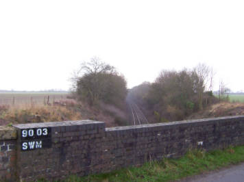
The photo above shows an ELR in use on a bridge. This bridge is at 90 miles and 3 chains (from London Paddington, as it happens), on route SWM. Strictly speaking, this should be SWM1, but as the two portions of this route have no overlapping mileages, there is no ambiguity.
Theoretically, all (ex-)BR routes had an ELR allocated, though it is possible that some did not (see Lines without codes). As this was a BR code system, one can expect non-BR lines (for there were many) not to have a code allocated, for example the Ministry Of Defence's Tidworth branch. Interestingly, some non-BR lines did receive ELRs, such as the Longmoor Military Railway (LMR). To enable records to be kept of other liabilities, some non-railway assets are given codes, for example the Somerset Coal Canal (SCZ) and Manchester Piccadilly Station Approach (SPA).
In connection with the early 2000s West Coast Main Line upgrade, a new form of ELR was introduced, applying only to sidings. Rather than being three letters and a number, the new form consisted of two letters and two numbers. These new ELRs all start or started "CR"; for numbers below ten a leading underscore is used, for example CR_7 for Tamworth Low Level Up Side (now reabsorbed into LEC2). It is not known what the letters "CR" mean.
From 1 April 2004, ELR codes were governed by the GEOGIS computer system (Geography and Infrastructure System, an asset-recording database). GEOGIS could only accept up to 25 tracks (each with their own ID code) for each ELR at any given mileage. This means that yards such as Healey Mills (HYM) and Tees (TSY) would, if and when GEOGIS were fully populated, need suffix numbers. However, after exactly 13 years' service, GEOGIS transferred to INM (Integrated Network Model). With far more functionality in INM than GEOGIS, it is assumed (but not confirmed) that the 25 track limit no longer applies.
Mileages are given in the form miles.chains. The chain is an imperial measure equalling 22 yards; there are 80 chains in a mile. As the majority of railways were built in the nineteenth century, it is usually more convenient to stick with older units of measurement, rather than try to convert all records to modern standards. Where, for interest's sake, other units are used, these are noted in the appropriate entry.
Any instances where data is uncertain or unknown are shown with question marks or an appropriate note. Further information to fill in the gaps is always welcome, as would information regarding mileages of stations, junctions and other assets of interest on those routes where full data is unknown.
The statement Listed as…
refers to differences between various official documents.
The list of Engineer's Line References is, as far as can be ascertained, complete. At the end of the table (lines without codes
) is a list of lines which, as far as is known, do not have their own code. Many of these routes will not have codes (e.g. railways never part of the national railway system), many are incorporated into other routes (e.g. Victoria Station and Pimlico Railway, now in VIR), and many simply cannot be identified at this stage. Any further information to update these shortcomings is welcome. The London Underground equivalent system is also included.
The ELRs themselves, together with the definitions, have come from various official sources. Mileage information has come from a variety of official and unofficial sources, and datum information entirely from unofficial sources.
These lists do not purport to show which routes are in current use and which are not. This information is readily available from other sources.
Most ELRs in this list have an associated hyperlink. Clicking this will take you to a mileage file. Each of these files has the major mileages for that ELR: junctions, stations and anything else that may be of interest. Stations are shown in capital letters, and other features in sentence case. Mileages in parentheses are not on that ELR, but are included for reference. As with the main ELR list, mileages preceded by ≈ are approximate. Features known to have existed but for which the distance is unknown are shown in the relevant place with a gap in the mileage column. Assistance filling in these gaps would be appreciated.
Links for ELRs at junctions take the viewer to that ELR, allowing the user to 'click through' a route without having to go back to the index pages each time. Stations open at 1 April 1994 (privatisation) or closed but appearing in official documentation, plus any subsequent alterations, have additional links to the relevant station entry (full station index here) allowing the user to find the station operator, for example, quickly.
Please note that sometimes mileages vary between sources: this may be because of a remeasuring or alteration of the assets (e.g. platform lengthening, track slewing).
To help them identify bridges quickly and easily, British Rail's civil engineers produced 'bridge books'. Two showing the railway in schematic form, including station and junction mileages, are available from this diagrams page.
Please click here for lists of current stations with their respective ELRs, mileages and operators.